IISc’s neighbourhood has a long and rich history
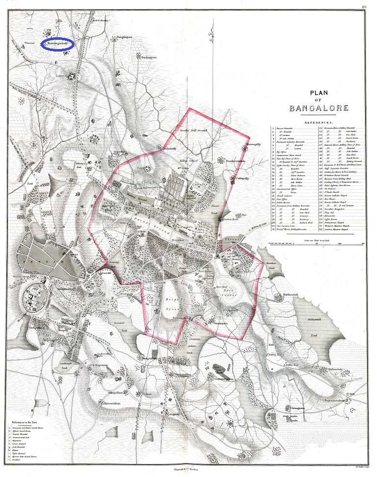
In the late 1890s, JN Tata was hunting for a suitable location for what eventually came to be known as the Indian Institute of Science (IISc). By the early 1900s, Bangalore had become the frontrunner to host the research institute, not least because of the wholehearted support it received from Mysore State. Besides startup capital and an annual grant, the State promised to provide land in the city for Tata’s ambitious initiative, an offer both Tata and the Government of India found hard to resist. And thus IISc found a home in Bangalore. While the story of how the Institute came to occupy 371 acres and 11 guntas of prime real estate in the north of the city has been well chronicled, we are only now beginning to piece together a deeper historical account of the land in and around IISc.
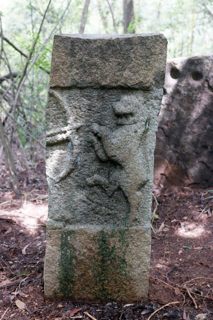
Hulibete veeragallu in IISc
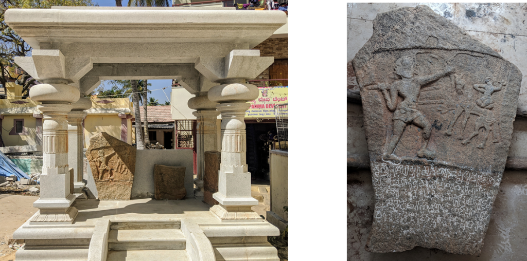
One day, in the late 1970s, young Vibhavaree and Sameehana excitedly dragged their father through thorny shrubs in the northeastern part of the campus of IISc, where the family lived from 1976 to 2002. “I was truly shocked that the children were wandering around snake-infested areas in the campus,” recalls their father SN Balasubrahmanyam, who was then a professor in the Organic Chemistry Department. Still recovering from the shock, he followed his children as they scurried along the unkempt terrain. He was eventually led to a stone, which Vibhavaree and Sameehana had accidentally stumbled upon. The children’s excitement was justified – this was no ordinary stone. It was a veeragallu.
A veeragallu – or hero stone – is a stone sculpture erected in honour of a person martyred in an act of extraordinary valour. Most veeragallus commemorate civilians and rarely soldiers or royalty. The sculpture typically depicts the martyr in action: defending his or her town against enemies (ooralivu veeragallu), fighting a boar (handibete veeragallu), fighting off cattle raiders (turugol veeragallu), defending a woman’s honour (penbuyyall veeragallu), entering the funeral pyre of a dead husband (sati veeragallu), or fighting a tiger (hulibete veeragallu). “There are many reasons for which a person may have sacrificed his life. And in their names these stones are erected,” explains Sundara Adiga, a former archaeology professor from Karnatak University in Dharwad.
The children’s excitement was justified – this was no ordinary stone. It was a veeragallu
According to Adiga, most hero stones found in the Karnataka region were made between the 8th and 17th centuries. These stones, which show a great deal of regional variation, also differ in style depending on the period. “For instance, a veeragallu made during the Ganga period is likely to be very plain,” says KR Narasimhan, a Kannada scholar and epigraphist. But veeragallus made during the more prosperous Hoysala period can be more intricate. “[During] the Hoysala period, we have stones that have beautiful narrations with elaborate panels and inscriptions,” adds Lathashree Kolla, a public archaeologist. The presence of inscriptions in particular are useful to historians since they may contain additional information, such as the name of the martyr, the place and date of the incident, and the reason for the encounter.
The stone at IISc, which Balasubrahmanyam’s children chanced upon, is a hulibete veeragallu. Though part of the stone is missing – it has been cut down the middle – it clearly shows the left hand of the martyr holding a bow, while the missing right hand is about to launch an arrow at what looks to be a pouncing tiger.
The IISc veeragallu is only one of three hulibete veeragallus that are known from Bangalore – the others are in the western (Bangalore University campus) and the southeastern (near BTM bus stand in Madivala) parts of the city. But it lacks an inscription. “It’s difficult without epigraphy, [but] in the absence of inscriptions, we work with styles, jewelry, weaponry,” says Lathashree. The photographs of the IISc hulibete veeragallu were studied by R Sesha Sastry, a former professor from the Sri Krishnadevaraya University in Anantapur, Andhra Pradesh, and one of Karnataka’s foremost veeragallu experts. He assesses it to be from the 10th century, when Bangalore was under the rule of the (Western) Gangas. According to him, the hulibete veeragallu in Bangalore University is likely to be either from the 7th or 8th century, also during the reign of the Gangas, and the third one in Madivala is from the 14th century, when the Bangalore region was part of the Vijayanagara empire.
The wildcats depicted in these stones are almost certainly tigers, as the noted tiger conservationist Ullas Karanth points out, since the word “huli”, which means tiger in Kannada, is used in similar veeragallus where inscriptions are available. This is not surprising – tigers roamed all across the Deccan Plateau and the Western Ghats until not too long ago. Moreover, it is unlikely that killing a leopard, which weighs less than 60 kg, would be commemorated. But if one kills or gets killed by a 200 kg tiger, it is a story worth immortalising in stone.
Medaraningahalli
It is entirely possible that the area around the hulibete veeragallu at IISc might have other hidden archaeological artefacts that will shed more light about the place from this period. But we do know more about its recent history, thanks to a Kannada inscription from 14 November 1669 carved on a boulder in the Kaadu Malleshwara temple (referred to in the inscription as the Mallapura Mallikarjuna temple) on 15th Cross, just off Sampige Road, in Malleswaram. It records the gifting of a village called Medaraningahalli to the temple by the then ruler of Bangalore, Ekoji Rao (the step brother of Shivaji Bhosala I, the famous Maratha king). The term “gifting” as used here essentially meant that tax revenues from the village would be diverted to the temple instead of being collected by the king’s revenue officers. This method of using tax revenues to meet the expenses of important temples was then a prevalent practice. And the “authorisation permit”, a royal edict, would be inscribed on stones in the vicinity of the temple or the village.
The proclamation inscribed in the temple reads (with the English transliteration):
೧. ಸೌಮ್ಯ ಸಂವತ್ಸರದ ಮಾರ್ಗಶಿರ ಶುದ್ಧ (೧/೨ ?) ಲೂ
(1. saumya saṃvatsarada mārgaśira śuddha (1/2 ?) lū)
೨. ಶ್ರೀಮತು ಮಲ್ಲಪುರದ ಮಲ್ಲಿಕಾರ್ಜುನ ದೇವರ ದೇವ ಮಾನ್ಯಕ್ಕೆ ಯಕೋಜಿ ರಾಯನ ಬೆಂಗುಳುರ
(2. śrīmatu mallapurada mallikārjuna devara deva mānyakke yakoji rāyana beṃguḷura)
೩. ಮಹನಾಡು ಕೇಳಲಿಕಾಗಿ ಮೇದರನಿಂಗಹಳಿಯ ಧರ್ಮಕ್ಕೆ ಕೊಟ್ಟನು ಕೋಟಿ ಚಂದ್ರ ಸೂರ್ಯರು
(3. mahanāḍu keḷalikāgi medaraniṃgahaḷiya dharmakke koṭṭanu koṭi caṃdra sūr-yaru)
೪. ಉಳ ಕಾಲಉ ಧರ್ಮಕ್ಕೆ ಕೊಟನು ಯಿ ಧರ್ಮಕ್ಕೆ ವಕ್ರ ಮಾಡಿದವರು ಕತ್ತಿಯ ಕಾಗಿಯ ಚಂಡಾಲರ ಜಲ್ಮ
(4. uḷa kāla:u dharmakke koṭanu yi dharmakke vakra māḍidavaru kattiya kāgiya caṃḍālara jalma)
೫. ದಲಿ ಹುಟುವರು
(5. dali huṭuvaru)
೬. ಮುಸಾಲಮಾನರಾದವರು ಮಕೆಯಲಿ ಹಂದಿತಿಂದ ಬ್ರಾಹ್ಮಣ ಚೆತ್ರಿ ವೈಶ್ಯ ಸೂದ್ರ ಕಾಸಿಯಲಿ ಗೋವ
(6. musālamānarādavaru makeyali haṃditiṃda brāhmaṇa cetri vaiśya sūdra kāsiyali gova)
೭. ಕೊಂದ ಪಪಕೆ ಹೋಗುವ
(7. koṃda papake hoguva)
The text of this inscription is as provided in Volume 9, Bangalore Supplement, of Epigraphia Carnatica by B Lewis Rice (line numbers are not part of the original inscription, but adding them is a default practice).
This edict, whose spellings and terms may vary from what would be considered correct today, roughly translates into English as:
“Heeding to the request of the people of Bengaluru, for as long as the Sun and Moon exist, Ekoji’raya gifts rent free Medarlingahalli to the Mallikarjuna temple in Mallapura. One who violates this grant will be born a donkey, crow, chandala. A Musalman [violator] will attract the equivalent [sin] of eating a pig in Mecca. A Brahmana, Chaitri, Vysya and Shudra will attract the equivalent [sin] of eating a cow in Varanasi.”
This inscription is significant for two reasons. One, it tells us that Malleswaram, or Mallapura as it was then called, existed at least 230 years before it was supposedly designed by the British Engineer Standish Lee, then working for Mysore Government.
And two, it refers to the village of Medaraningahalli. An 1854 Bangalore map and other older maps show this to be a village of reasonable size in North Bangalore.
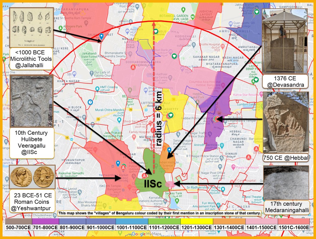
When these old maps are digitally superimposed on today’s maps, it clearly shows that Medaraningahalli would have spanned the eastern part of IISc campus in and around the swimming pool, the Staff Colony of CPRI (Central Power Research Institute) and the area beyond New BEL Road into CPRI.
The 1854 map refers to the village of Medaraningahalli, which once included the eastern part of IISc
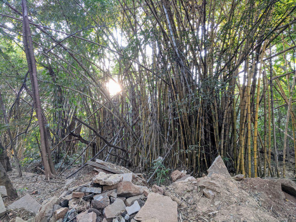
Medaraningahalli is named after Medaras, an old tribe found in parts of Karnataka, Tamil Nadu and Telangana. Traditionally, the Medaras worked with bamboo – they would gather fresh green bamboo from nearby forests and fashion them into baskets, mats, and other items. Interestingly, even today, we find bamboo thickets near the swimming pool and Jubilee Gardens in IISc though it is not clear whether they are remnants of old bamboo vegetation or were planted more recently.
It was not uncommon in those days for a village to be named after the predominant tribe or a caste from the village. We have numerous examples of this practice in Bangalore: Kumbarapete (town of potters), Byadarahalli (village of hunters), Agrahara (Brahmin settlement), Ganigarahalli (village of oil extractors), Gollahalli (village of cowherds), Kurubarahalli (village of shepherds). Bangalore, in fact, has at least two other places named after the Medaras: Medarahalli near Chikkabanavara and a Medarapete in the old pete area of the city.
So what happened to Medarningahalli? One possibility is that the village was evacuated sometime in the 1890s, when the devastating bubonic plague struck Bangalore and its surroundings. We know that several other villages and parts of the city were abandoned to escape the dreaded epidemic, including perhaps Devasandra.
Devasandra
The northeastern parts of the IISc campus originally belonged to Devasandra, a village that has existed for at least 650 years. About 100 m from the Centenary Visitors House (CVH) gate at IISc is an inscription stone from 1376 inside the Balanjaneya temple. This inscription in Tamil records the gifting of land in Devasamudra (the old name of Devasandra) to a few Brahmins.
The word “samudra” in Devasamudra refers to a lake in the vicinity of the village. Over time, “samudra” changed to “sandra”. We have several other examples of names of places in Bangalore with “sandra” in them: Allalasandra, Jakkasandra, Bommasandra, Channasandra and so on. The Devasandra lake (also known as Geddalahalli lake) is now filled over, and on it stands the upmarket RMV 2nd stage.
The 1376 Devasandra inscription uses the royal epithet Hinduraya Suratrana (“Hindu Sultan” in Sanskrit) for King Bukkaraya, one of the founders of the Vijayanagar kingdom. The Vijayanagar kingdom emerged from the collapse of the Hoysalas following a series of invasions by the Delhi-Bahmani Sultanates down south. The founders of the Vijayanagar kingdom, who successfully stopped such invasions from the north, assumed the title of Sultan of the Hindus.
The Devasandra inscription is not the only one in the city that is in a language other than Kannada. Inscriptions in Tamil and Telugu were quite common after the 10th century, a testimony to the cosmopolitan nature of the region for over a thousand years.
Like Medaraningahalli, Devasandra also seems to have been affected by the 1890s plague and the village was relocated about a kilometre north of where it originally existed. When people left their villages and established new ones, they often named the new settlement after their native village.
Hebbal
About 3.5 km northeast of IISc in Hebbal village is an ooralivu veeragallu with inscription in Kannada. Discovered only in June 2018, it is from around 750 CE, and is now considered to be Bangalore’s oldest stone inscription. The inscription mentions the name of the place where it is installed as Perbolalnaadu Muvatu (muvatu in Kannada is 30). PV Krishnamurthy, an eminent historian and epigraphist, who deciphered the inscription, has derived the etymology of modern day Hebbal from Perbolalnaadu as: Periya + Polal (Periya = big, Polal = town) -> Perbolal -> Pebbolal -> Pebbol -> Pebbala -> Hebbala. Adding a numeral to the name of an important town was a common practice. It indicates the number of smaller towns and villages under its jurisdiction. In fact, other inscriptions from this period show that Hebbal was then part of a larger country called Gangavadi 96000 and was ruled by the Ganga king Sripurusha residing at Manne near Nelamangala. Ganagavadi covered the areas of modern day Kolar, Bangalore, Krishangiri, Salem, Erode, Mandya, Mysore, Coorg, Chikamagalur, Shimoga and Tumkur districts.
The 750 CE ooralivu veeragallu is dedicated to Hebbal native Kittayya who saved his town from being destroyed by the Rashtrakutas. Because the Hebbal-Kittayya inscription is Bangalore’s oldest inscription, Kittaya is the earliest known resident of the city. Had he failed to defend the important town of Hebbal, this part of Bangalore may have taken a very different historical course.
It is also worth mentioning that in close proximity to the Hebbal veeragallu in Bhoopasandra, in the vicinity of the Hebbal lake, lies an 8th century Durga idol with a fragmented Kannada inscription. The idol was discovered and rescued from destruction when the Outer Ring Road was being built in the late 1990s. Durga idols are commonly installed and worshipped alongside water bodies. The inscription refers to wetland farmers, suggesting that the Hebbal Lake may have existed at least 1,200 years ago.
Had Kittayya failed to defend the important town of Hebbal, this part of Bangalore may have taken a very different historical course
Yeshwantpur
But the neighbourhood of IISc has a history that goes back even further in time. People who lived in these parts some 2,000 years ago seemed to have had trade relations with Rome during its heady days. On 17 April 1891, when building the railway line about 1.5 km west of IISc (close to Yeshwantpur Railway Station), workers discovered an earthen pot with 163 denarii (plural of denarius, an ancient Roman silver coin) from 23 BCE to 51 CE, a period when Rome was ruled by Augustus, Tiberius and Caligula. The existence of trade ties between people in the Bangalore region and Rome is supported by the discovery of Roman coins in other parts of the city as well. For instance, in 1965, when the runway for the HAL airport was being built, a pot with 256 denarii from the same period was unearthed. A similar discovery of Roman coins was made by the historian DR Gordan in 1945 in Bellandur.
Jalahalli
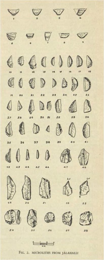
The earliest evidence of human habitation in the IISc neighbourhood has been discovered in Jalahalli, about 4 km northwest of IISc campus. In 1946, a British archaeologist and commander in the Royal Indian Navy KRU Todd, while convalescing in the Indo-British hospital at Jalahalli, was intrigued by the granite quarries adjoining the hospital. As soon as he recovered, he visited the site, where he discovered several hundred microlithic (small-stone) prehistoric tools made from quartz, rock crystal and red jasper. These tools were so numerous that he thought that the site was a factory for making stone tools. The artefacts are now housed in the British Museum in London. Subsequently, in 1948, he published an article about the discovery titled “A Microlithic Industry in Eastern Mysore” in Man, now called the Journal of the Royal Anthropological Institute. A few years later, M Seshadri, the Director of the Mysore Archaeological Department, after studying the implements in the British Museum, concluded that these tools were from the pre-iron age era, 1000 BCE or earlier, making Jalahalli the site of the earliest known human settlement in the region.
Not many university campuses in the world can boast of a history as rich as this
The stories about the different villages and towns that make up this part of Bangalore are disparate. As we discover more, we will someday be able to weave together these diverse strands into a more comprehensive historical narrative of the region. But we already know that IISc’s neighbourhood has a long history – there were well-established villages 500 to 1,500 years ago, a thriving international trade centre 2,000 years ago, and a settlement where artisans made sophisticated stone tools 3,000 years ago. Not many university campuses in the world can boast of a history as rich as this.
Note: Even when not mentioned, all dates provided in the article are in CE (Common Era)
Udaya Kumar PL, a passionate Bangalorean, works in the technology sector and is the founder of a citizens group, Inscription Stones of Bangalore. This group is focussed on securing Bangalore’s endangered inscriptions and strives to educate people about the pre-16th century history of Bangalore and its localities.