Kusala Rajendran, a seismologist at IISc, takes us into the world of earthquakes, and tells us why predicting them is far-fetched at the moment
(Photo courtesy: Kusala Rajendran)
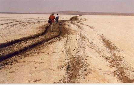
Inspecting trenches in a no man’s land, at the India-Pakistan border, stood Kusala Rajendran and her husband CP Rajendran. Surrounded by the BSF jawans, the Rajendrans were donning the detective’s hat: they looked for evidence hidden below the surface, hoping that it would give them a glimpse into the past.
Much of this scene plays out every time the duo sleuth for clues on old earthquakes. Except that, when they are in less risky regions, they don’t have BSF jawans for company. Scientists who study past earthquakes like them are palaeoseismologists. Besides inspecting regions that are susceptible to earthquakes, a part of their research is devoted to assessing the seismic vulnerability of places where critical facilities like dams, chemical or petrochemical facilities and nuclear power plants are being planned. The Rajendrans are professors based out of Bangalore – Kusala Rajendran is at the Department of Earth Sciences in IISc and CP Rajendran is at the Jawaharlal Nehru Centre for Advanced Scientific Research’s Geodynamics unit.
Investigations at the Rann of Kutch
At the India-Pakistan border, the Rajendrans explored the white landscapes of the salt desert – Rann of Kutch – from 1997 to 2008. Two massive earthquakes have struck the region in recent memory: one in 2001 and before that, in 1819. “The British kept a record of the 1819 earthquake. We wanted to find out if the region experienced earthquakes before that,” says Kusala Rajendran.
During this quest, they decided to dig about 15 trenches around a structure created by the 1819 earthquake. About 60-70 km long, 16 km wide, the structure is a natural dam named the Allah Bund. In two of the 15 trenches near a ruined fort around the Allah Bund, they finally found their gold mine: brick and charcoal pieces from an old civilisation, probably destroyed by an earthquake before 1819. Most often, palaeoseismologists hunt for cultural remains in earthquake-ravaged human settlements.
These remnants are often trapped in thin layers of sand, which distinctly stand out in the trenches, among other layers of sand and rock
These remnants are often trapped in thin layers of sand, which distinctly stand out in the trenches, among other layers of sand and rock. This layer of sand called sand blows act as archives of tremors because they preserve materials that get trapped in them. The shear motion caused by seismic waves tend to increase the pore water pressure in the water-logged sand, forcing a jet of liquid sand – sand blow – out onto the earth’s surface. As time goes by, new layers of sand settle over it, leaving it for palaeoseismologists to uncover.
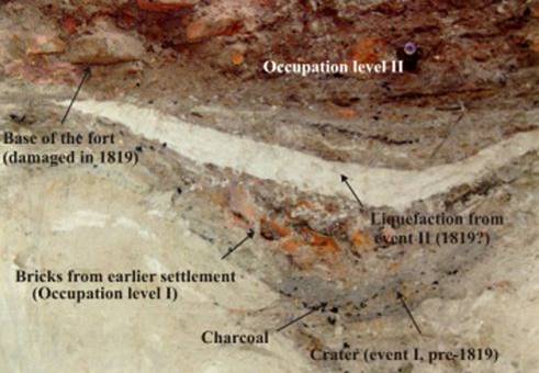
Finding remnants mean that they can estimate the age of materials using carbon dating. “If we find a brick that is 100 years old,” she says, “we can infer that the earthquake occurred after the brick was made, which means it is younger to the brick”. To corroborate their findings, they also gather evidence from archaeology and history, allowing them to trace past earthquakes.
For instance, from their explorations at the Rann of Kutch, they predicted that an earthquake had occurred in the Kutch region about 1000 years ago. Later, they found a historical document that confirmed that an earthquake had indeed occurred in the region around 893 AD.
The advent of earthquake science
Besides investigating the history of earthquakes in a given place, Kusala Rajendran’s research also attempts to learn more about the source of earthquakes: its depth and the amount of energy it releases.
Seismology is relatively young, unlike many other sciences. The theory that would lay the foundation for seismology was proposed in 1912, when a German geophysicist, Alfred Wegener, observed that continents on a map were shaped like pieces of a jigsaw puzzle that had been pulled apart. He deduced that continents are not static; they move. Although others made similar observations before, he was the first to gather evidence to support this theory. He presented his theory of continental drift in a book titled The Origin of Continents and Oceans. He claimed that all continents were once part of a single landmass called Pangea. This supercontinent separated into two continents, Gondwana and Laurasia, 175 million years ago, and eventually into the four major landmasses that we see today: Afro-Eurasia, the Americas, Antarctica and Australia. But this idea did not find favour with academics and was initially ignored.
Now we know that Wegener was right. But what he couldn’t explain was why continents drift. He did not know that they move because they lie on the mobile tectonic plates, which make up the earth’s outermost layer, the lithosphere – comprising the crust and uppermost region of the mantle. Giving tectonic plates its mobility is the flowing inner mantle, lying just below the plates.
At around the same time, scientists gradually began to learn more about earthquakes. The early 1900s saw the sprouting of several seismic stations around the world to measure these events. This paved the way for global collaboration among geologists. Then in 1935, Charles Richter developed the Richter scale, a method to measure the intensity of earthquakes, helping people understand the severity of an earthquake. Because it is a logarithmic scale, an earthquake measuring 6 on this scale is ten times larger than that measuring 5. “With this information, scientists began plotting earthquakes on a map, and they realised that they were not just spatially random, but were following certain patterns,” she says.
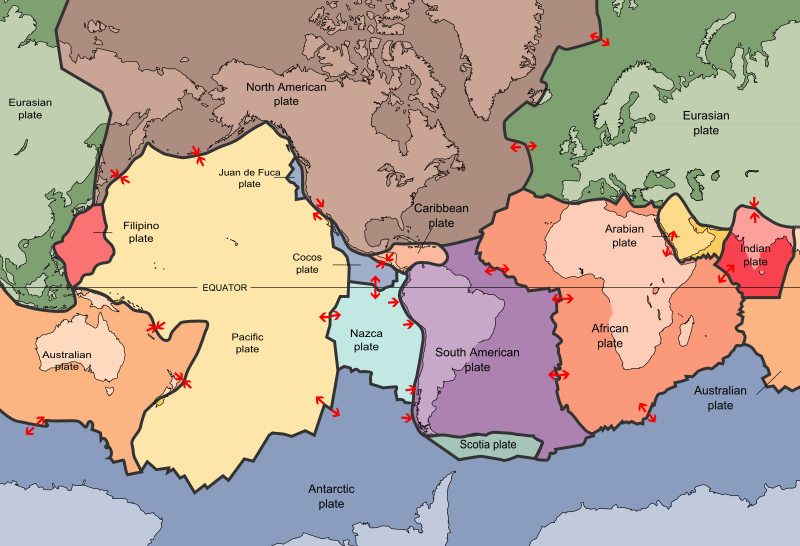
Seismologists learnt that earthquakes occur in regions where tectonic plates meet, along their boundaries. There are seven major tectonic plates and several smaller ones. The major plates include the African, Antarctic, Eurasian, Indo-Australian, North American, Pacific, and South American Plates. When plates collide against each other, they release a massive amount of energy causing earthquakes. For instance, the collision between the Indian and Eurasian continental plates, which created the Himalaya, is an active earthquake zone. And when continental and oceanic plates collide, earthquakes like the one that caused the 2004 Indian Ocean tsunami occur. Here, the collision between the two plates pushed the oceanic plate beneath the continental plate, deforming the floor of the ocean, resulting in massive tidal waves. About 90 percent of them take place in regions bordering the Pacific, Juan de Fuca, Cocos, Indian-Australian, Nazca, North American, and Philippine plates called the Ring of Fire.

Exploring its unpredictability
Earthquakes, however, don’t always occur near plate boundaries. In recent years, scientists have observed that they also strike regions within a plate, which were long considered immune to such attacks – the Stable Continental Regions (SCR). An example of an SCR is the Rann of Kutch, where the Rajendrans were fishing for evidence on past events. “We understood that earthquakes do happen in stable regions, and they can be dangerous, not because they are very large, but because they’re unexpected. People are not ready; buildings are not constructed strong enough to withstand tremors, so the damage is massive.” Although significant SCR earthquakes have occurred in the eastern United States and elsewhere, in India, it was Maharashtra’s Killari (Latur) – a region with no past history – that sparked an interest in SCR. This 1993 quake claimed the lives of 10,000 people.
Investigations revealed that even the stable regions of a tectonic plate harbour weak spots – cracks or fissures – called faults, where earthquakes strike. “When stresses from the plate boundaries are passed into the stable regions,” Kusala Rajendran adds, “they will activate some of the pre-existing faults even in the so-called stable regions and generate quakes.”
Earthquakes, however, don’t always occur near plate boundaries. In recent years, scientists have observed that they also strike regions within a plate, which were long considered immune to such attacks – the Stable Continental Regions (SCR)
These weak spots are the result of years of tectonic activities in the earth’s interior. According to Kusala Rajendran, continents have moved around several times during the long history of the earth: they have come together; they have separated; they have changed their geographic position; or they have given rise to new geologic formations, like the Himalaya.
Some of these plate tectonic motions have pushed tectonic plates away from each other – creating rifts in the landmass. Active rifts release molten hot rocks called magma onto the earth’s surface, filling up space between the two separated plates. India is home to the Narmada valley rift, albeit a dead one, meaning there are no tectonic activities anymore. But there’s a catch. Previous tectonic activities have created weak spots in the rift. So they can spur earthquakes, when activated, as we saw in 2001 in Gujarat and in 1997 in Jabalpur, Madhya Pradesh.
Investigations revealed that even the stable regions of a tectonic plate harbour weak spots, which are cracks or fissures – called faults, where earthquakes strike
Another stable region that continues to intrigue scientists is the source of the 1967 Maharashtra’s Koyna earthquake. With a magnitude of 6.3 on the Richter scale, it killed over 180 people. Scientists believe that the construction of a dam in 1962 triggered the quake, whose source was near the Shivaji Sagar Lake formed by the dam. Such tremors are referred to as reservoir-triggered earthquakes. Today, SCRs are garnering a lot of attention from the international scientific community.
According to Kusala Rajendran, India is a classic laboratory to study a variety of earthquakes. “She explains that the landmass of India sees an impressive diversity of earthquakes: quakes in the Himalaya due to continental-continental collision, 2004 Indian Ocean tsunami from the plate collision, Gujarat’s devastating earthquakes triggered by reactivation of faults within a rift, Latur earthquakes by reactivation of faults that are not associated with a rift, and Koyna’s reservoir-triggered quake.
Holy Grail of seismology
In spite of all that we have learnt over the past few decades, we are a long way from a comprehensive understanding of earthquakes, and also from the holy grail of the field of seismology: being able to predict earthquakes.
‘We don’t know enough about earthquakes, especially the physics behind the phenomenon, to accurately predict them’
“We don’t know enough about earthquakes, especially the physics behind the phenomenon, to accurately predict them,” says Kusala Rajendran. She adds that as scientists learn more, they find that there are differences between them. So far, they haven’t been able to make accurate predictions, including predicting the expected location, data and the size of the earthquake. It is a bigger challenge, particularly in the SCR regions because the intervals at which they strike are long, say over thousands of years in Latur.
But some scientists keep at it. But when they fail to forecast a quake, it can sometimes prove perilous to them. In 2009, six geologists were convicted of manslaughter, after failing to predict the 2009 earthquake in the Italian town of L’Aquila that killed 29 people. However, they have been acquitted now.
Kusala Rajendran believes that the reason we have not been successful in predicting earthquakes is because predictions are based on statistical models, which are built without a clear understanding of the dynamics of the earth beneath our feet. She explains, “Models are based on assumptions. We don’t have the means to know what is happening in the Earth, as the earthquake source maybe 10 or 15 km deep in most cases. We have very little idea of the physical properties of rocks, or the nature of faults at that depth, not to mention their complex interactions. I don’t believe that earthquake prediction is an easily achievable goal.”
Although prediction may be challenging, monitoring is important. She says, “In the United States, for example, reservoirs are monitored carefully even at regions with low-level seismic activity.” During her PhD, a nuclear power company funded a project at the University of South Carolina. As part of the project, she was tasked with maintaining seismic stations and providing reports of seismic activities around three reservoirs in South Carolina. She adds, “Such arrangements help healthy interactions between the industry and academia; it provides employment where training in research can be best utilised. Of course, these situations are driven by the existing laws of the country and its regulatory systems. Perhaps, this applies to many areas, not just in the case of earthquake monitoring.”